
New tool reveals shallow groundwater elevations
2 Apr 2025
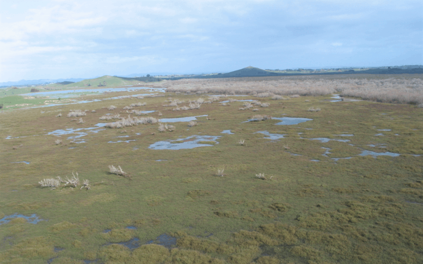
Media release: NIWA | A new online tool that identifies areas at risk from groundwater flooding has been developed by New Zealand scientists.
Groundwater flooding occurs when the water table rises close to the surface, causing issues even before the water visibly floods the ground.
The Shallow Groundwater Screening Tool, which identifies areas at threat from water table rises, will help hazard and land-use decision-makers understand the scale of the problem and which areas are likely to be the most vulnerable, says lead for the Future Coasts Aotearoa programme, NIWA Chief Scientist Coasts and Estuaries Dr Scott Stephens.
Groundwater - also known as the water table - rises with sea levels, particularly in coastal and low-lying areas, and it can be pushed even higher by persistent rainfall. Groundwater flooding is often overlooked as a threat, however it is a hazard that traditional flood defences such as stopbanks and seawalls cannot contain because the water comes up from underneath. When the groundwater rises, it can saturate soil and structures, weaken infrastructure, increase liquefaction risk and worsen surface flooding from heavy rainfall. As sea levels continue to rise, groundwater levels in the coast zone and close to tidal rivers will increase accordingly. Persistent heavy rain also pushes up the water table, a phenomenon which contributed to South Dunedin’s flooding in October 2024.
It's not all bad - shallow groundwater can also be beneficial for some ecosystems and for buffering droughts.
The first-of-its-kind online tool, developed as part of the NIWA-led Future Coasts Aotearoa research programme, shows areas that could be exposed to shallow groundwater hazards, right now, based on existing groundwater measurements, says Dr Stephens.
"Increased flooding events will be a real driver of change in many places. Rising groundwater will destabilise roads and damage buildings. It could make farming uneconomic. Stormwater pipes will be persistently full. Councils and decision-makers need an accurate picture of current shallow groundwater levels to prepare for future risks by identifying what areas could be exposed to shallow groundwater as sea levels continue to rise. This tool will be useful for local, district and regional councils, engineers, infrastructure providers, and rural communities, as well as individual citizens who want to make better-informed decisions for their future."
Water resource consultancy Kōmanawa Solutions created the tool. Its founder Zeb Etheridge says that we are interested in the shallow water table because that's the part of the groundwater system that's most affected by sea level rise.
"Two-thirds of New Zealanders live in coastal areas, meaning much of our infrastructure and land use falls within these vulnerable zones. Understanding this issue is critical for future planning."
The Kōmanawa Solutions team pulled together 2.4 million real-life readings of groundwater depth from around the country. To fill in the gaps, they used machine learning trained on factors that influence the water table, such as land elevation, soil type and nearness to waterways. Mr Etheridge describes the result as a risk screening tool to manage hazards, guide adaptation planning for existing land use choices, and plan future developments.
"Local authorities are likely to undertake more detailed assessments of the areas that are shown to be potentially exposed before making any significant decisions," he says. The tool is designed so that the certainty of detecting risky groundwater levels can be dialled up or down, as can the depth of groundwater that is of interest.
Further updates from the research team, which includes NIWA, Kōmanawa Solutions, GNS Science, and the University of Canterbury, are in development. These include projections of rising water tables as sea levels rise and land subsidence. The team will also investigate the risk of groundwater becoming saline as seawater infiltrates it.
The tool can be found at www.niwa.co.nz/shallow-
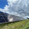
Lodestone Energy completes equity raise
Thu 24 Apr 2025
Media release | Lodestone Energy, New Zealand’s leading solar energy company, has recently completed a successful capital raise for an additional $50 million, adding to the $50 million development fund it raised in 2024.

Global livestock industry exposed for rampant rainforest destruction, despite no-deforestation pledges
Wed 23 Apr 2025
Media release | Greenpeace Aotearoa says a new investigation revealing that the world’s largest meat company, JBS, will fail to meet its deforestation-free commitment is yet more proof of false promises from the intensive livestock industry.

Balance needed in Waste Minimisation Act – Zero Waste Network
Wed 23 Apr 2025
Media release | The Government announced its proposals for updating the Waste Minimisation Act and the Litter Act.

Concern over climate change declining
Tue 22 Apr 2025
Ipsos New Zealand has released the findings of a new 32-country study for Earth Day, perceptions of the risks facing us from the climate crisis as well as where is the responsibility for greater action.
Environment Court rules Mackenzie biodiversity deserves bespoke protection
17 Apr 2025
Media release | In a decision years in the making, the Environment Court has upheld EDS’s contention that Te Manahuna / the Mackenzie Basin’s significant ecology and indigenous biodiversity warrants a bespoke planning regime to protect it from farming intensification.

Straterra has a new name: the New Zealand Minerals Council
16 Apr 2025
Media release | Straterra has been renamed as New Zealand Minerals Council, says chief executive Josie Vidal.

NZCTU announces transformative policy vision for Aotearoa
15 Apr 2025
Media release | The plan would ensure that Aotearoa meets its climate obligations and guarantees a just transition for the workers and communities who will bear the brunt of the climate crisis and technological change.
NZ could make better use of natural processes to reduce flood risk
15 Apr 2025
Media release | New Zealand could make better use of natural processes to reduce the risk of flooding, according to research by the National Institute of Water & Atmospheric Research (NIWA).

New Zealand’s glacier volume down 42% since 2005
14 Apr 2025
Media release | Total glacier ice volumes in Aotearoa New Zealand decreased by 42 percent between 2005 and 2023, according to figures released by Stats NZ.

Global EV adoption fails to cut CO2
11 Apr 2025
There's little point in buying an electric vehicle if you're charging it with electricity generated by fossil fuels. In fact, when it comes to carbon dioxide emissions, your EV may be doing more harm than good.